

Update: Logging Review and Spring Sites of Concern – Fall 2026
September 29, 2026
- •
- •
- •
An Update on Logging Impacts in the Oldman Headwaters
Recap
Since late May, AWA has been in communication with multiple regulators and government bodies regarding the Logging Review and spring site visit, to mixed results. There has been progress on a few fronts, with preliminary discussions taking place with the Department of Fisheries and Oceans Canada (DFO), the Alberta Energy Regulatory (AER), West Fraser Timber Co., and accrediting bodies. We have continued our attempts to reach Alberta Forestry and Parks about our spring findings within Daisy Creek, where sediment has continued to be deposited in critical habitat for species at risk trout. Letters to DFO, AER, Forestry and Parks, and West Fraser can be found here.
Our spring site visit with fisheries biologist Matt Coombs was brought to the attention of DFO and Forestry and Parks due to the presence of ongoing erosion and sedimentation, sediment reaching mapped and unmapped critical habitat for native Bull Trout and Westslope Cutthroat Trout, and clearcut logging without any buffer over flowing channels that were not mapped as critical habitat. To accompany the photos and videos provided, turbidity measurements were taken which showed multiple instances of 480 percent or greater increases when comparing upstream versus downstream. Detailed notes on the sites reported to DFO and Forestry and Parks can be found in our spring update.
Continued Monitoring
Since the spring site visit, Matt has returned to Daisy Creek drainage during another rain event (42.9 mm on Jun. 28, 2026 and 57.2 mm on Jun. 29, 2026 at Vicary Creek station). Matt revisited sites from the spring visit where he and AWA noted concerns of sediment entering designated critical habitat for Threatened native trout along with issues of unmapped critical habitat that has been logged over.

Signs of sediment transport and movement past the sediment fabric on the bin walls of the bridge. Westslope Cutthroat Trout observed 700 m downstream, this sediment would cause direct harm to Westslope Cutthroat Trout. Photo credit: M. Coombs
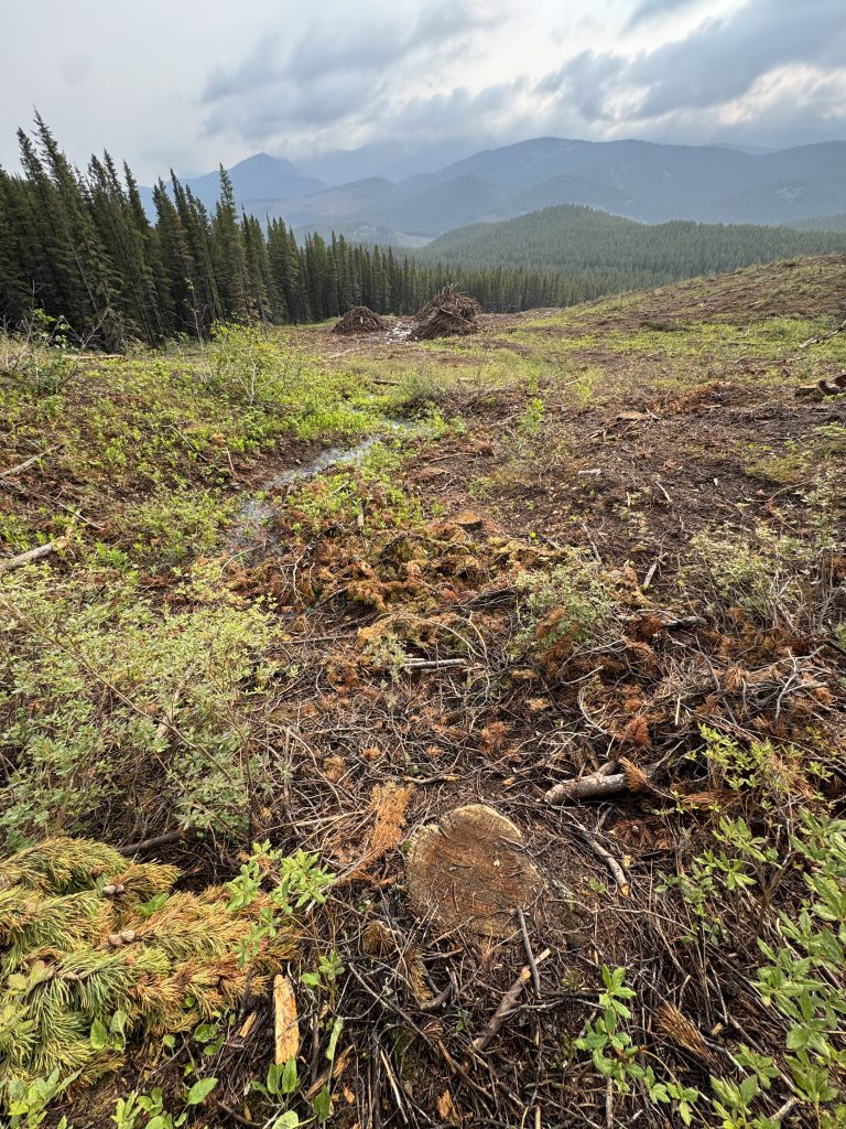
Unmapped tributary which is a groundwater spring; photos looking downslope. Critical habitat for Westslope Cutthroat Trout. Photo credit: M. Coombs

Upslope along the path of the unmapped tributary from where it branches into two flow paths near the slash piles. Photo credit: M. Coombs

Riparian vegetation removal under the bridge and erosion of the banks of the critical habitat stream. Photo credit: M.Coombs
AWA has yet to receive a formal response from Forestry and Parks in regards to the above site, which has been documented depositing sediment into native trout critical habitat. Since AWA’s initial email in the spring, Forestry and Parks replied letting us know that the sites of concern from our spring visit were referred to the Alberta Energy Regulator (AER).
Cameron,
This particular issue identified by the Alberta Wilderness Association is under LOC4111 and CNRL has the license, therefore, it’s been referred to the Alberta Energy Regulator.
Regards,
This was due to one of the sites being located along Coseka Road. Coseka Road leads to a now-dismantled Canadian Natural Resources (CNRL) facility, and CNRL holds the license for the disposition where this road is located, so therefore the road is related to an energy project which falls under the jurisdiction of the AER. Now, the AER has been quite responsive in regard to the site under their purview located along Coseka Road, and there are active efforts to clean sediment and improve erosion and sediment controls at the initial site from our spring visit. We also identified other sites that had similar issues with sediment being pushed onto the culvert from road grading for logging access, and these are also now slated to receive the same treatment, for which we are currently awaiting further updates. Most recently, photos from Sept. 21, 2026 show the sediment has been cleaned, although if another rain event occurs, sediment from the road could still enter the stream. (See examples of additional sites in the gallery below.)

Side-by-side comparison of before and after grading for logging access at a culvert which is critical habitat along Coseka Road. Photo credit: M. Coombs

Additional culvert where road grading pushed sediment into the culvert. Photo credit: M. Coombs

Additional culvert where road grading pushed sediment into the culvert. Photo credit: M. Coombs

Initial site of concern being tended to by AER which has seen sediment cleaning. Additional erosion and sediment controls are pending. Sediment from the road can still run off. Photo credit: C. Hunter

Top view of initial site of concern being tended to by AER which has seen sediment cleaning. Additional erosion and sediment controls are pending. Photo credit: C. Hunter
However, the AER acknowledged the sites of concern from our spring visit that were referred to them did not all fall under their jurisdiction, leaving one site of concern awaiting response from Forestry and Parks. AWA’s first follow-up email with Forestry and Parks was met with no response, and we recently sent an additional follow-up to which we are awaiting a response.
AWA also sought to find out if there was a Qualified Aquatics Environmental Specialist (QAES) present during the construction of a new crossing over the mainstem of Daisy Creek. Clarification is needed, as through federal DFO permitting, they require a Qualified Environmental Professional, or QEP. A QEP is required to construct a bridge in order to provide the necessary oversight and conduct a Bull Trout redd survey prior to fording (crossing) the creek with construction equipment. We were unable to get a clear and concrete response to this question; the statements were all simply “If it was required, it should have been done.” Further details are currently being sought.
In addition to sending letters to industry and government, on May 19, 2026, AWA sent a letter to the Sustainable Forestry Initiative (SFI) discussing our Logging Review and our concerns with West Fraser’s compliance with SFI objectives. On Jun. 11, 2026, per SFI’s suggestion, AWA filed a complaint with KPMG Forest Certification Services that highlighted West Fraser’s lack of compliance with SFI’s 2022 Forest Management and Fiber Sourcing Standards. On Jul. 14, 2026, we met with KPMG to discuss the findings from our Logging Review as part of their investigative process into our formal complaint. Investigations are ongoing, and a more detailed post about this can be found here.
Access to Information and Privacy (ATIP) request
On Jun. 2, 2026, AWA submitted an Access to Information and Privacy (ATIP) request for deviations from operating ground rules within Racehorse Creek and Livingstone River watersheds. However, our fee waiver for this request was not waived and we proceeded to pay for the records we were seeking after we reduced our timeframe from 2017–2026 to 2023–2026. ATI officers emailed to say files from the request are delayed until Oct. 8, 2026 due to requirements to get third-party information.
Logging in Tecumseh – Allison Creek
Logging in the region continues, with active logging occurring in Pelletier Creek, recent logging happening in Daisy Creek (Winter 2025), and pending logging in Tecumseh-Deadman Pass logging area, where the construction of a 30-foot bridge over Allison Creek is required to access the proposed cut blocks. This region is home to some of Alberta’s most unique forests containing ancient limber pine, white-bark pine (an Endangered species at risk), western white pine, ponderosa pine, western larch, rocky-mountain juniper, and Threatened Westslope Cutthroat Trout that live within the upper reaches of Allison Creek . These cut blocks are part of the Community Hazardous Fuels Reduction Program which is accelerating 10 years of harvesting into a compressed timeline of only a few years, and the cut blocks at Techumseh are massive in size, approaching 1,100 acres making them some of the largest clear-cuts within the vulnerable Oldman Watershed. The Defenders of the Eastern Slopes have recently set up a peaceful blockade and observation camp that has, as of Sept. 28, 2026, halted the construction of the bridge to access the logging. This group has also requested more detailed information on hydrologic assessment studies, fish and fish habitat studies, and information around how these clear-cuts fit into a comprehensive wildfire-protection strategy for the Crowsnest Pass.
Clear-cuts of this size undoubtedly have a drastic impact on the movement of water and therefore sediment. Recent findings from our Logging Review and spring site visit add to a growing body of evidence related to erosion, sedimentation, and loss of critical habitat linked to forestry activities in the Eastern Slopes. Observations from this review and continued monitoring raise serious concerns as to whether the forestry industry is meeting even the minimal requirements of the operating ground rules, and these issues are being found in active logging areas where the timeline for harvest has been compressed and accelerated from the Community Hazardous Fuels Reduction Program.
To view Logging Plans, such as Tecumseh – Allison Creek, take a moment to look at CPAWS Southern Alberta’s Logging Plan Viewer, a very handy and intuitive tool to understand logging plans in the Ghost, Elbow, Highwood, Oldman, and Crowsnest regions.
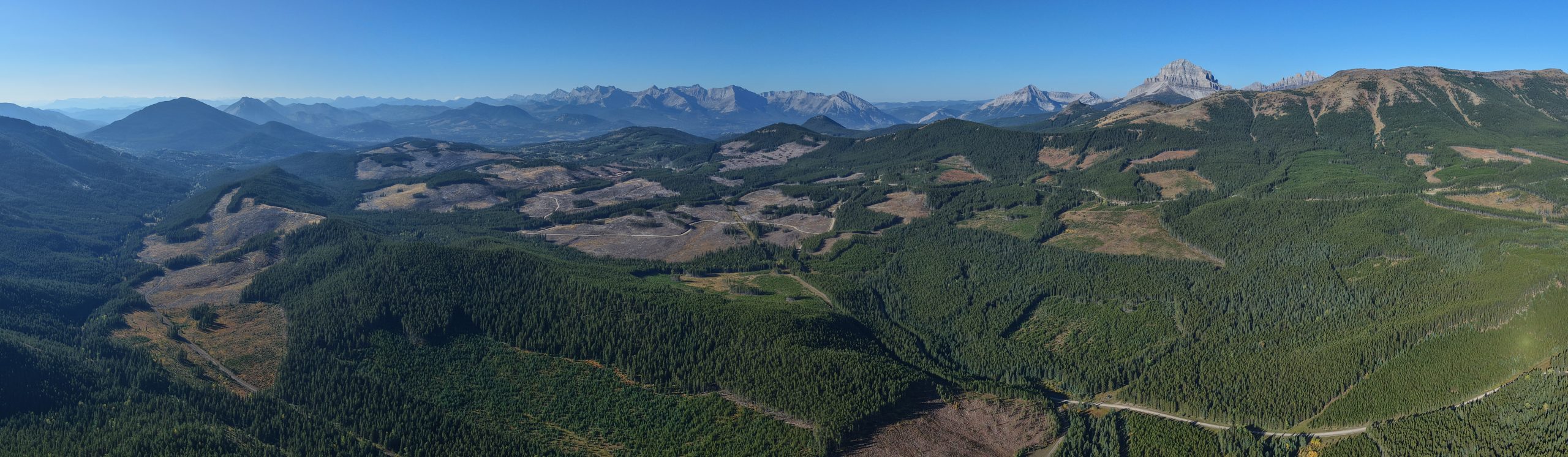
Aerial view of Pelletier Creek cutblocks, where some active harvesting is occurring. Photo credit: C. Hunter